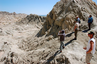
I took a field trip yesterday for the first time since going to see "King Lear" during senior year of high school. My seismology class headed out east of San Diego to check out some of the major faults, including a trace of the San Andreas, as well as some other cool geologic / seismological features. I'll do my best to recollect what we saw and its importance below, via pictures, of course.
Surface trace of the Elsinore Fault just northeast of Julian, CA, as it follows the creek in the bottom of the valley (not shown) as well as the linear "shoulders" in the hillside (center of photo).
Looking out over the Salton Trough near Borrego Springs.
Coyote Mountain and the Santa Rosas. Coyote has one trace of the San Jacinto fault along its western (facing) edge, while another trace abuts the western edge of the Sta. Rosas.
Fresh Imperial Valley grapefruits.
Trace of a splinter of the the San Jacinto along the west face of Coyote Mtn.
Evidence for 1 to 2 km of offset along the right splinter of the San Jacinto just east of Borrego Springs: an alluvial fan that has been shifted northwest (Pacific plate motion) in the last 1 to 2 million years. The Google Earth view (33.314965181082314, -116.2075424194336) is much better.
Looking southeast along the same offset.
The old shoreline of a full Salton Sea is about 12 m above sea level, right at the base of these hills.
The view of the Salton Sea from Travertine Rock is actually quite nice until you think about how polluted the water actually is.
Travertine-coated rock, meaning this used to be underwater during a previously-full version of the Salton Sea. The migrating delta of the Colorado River tends to fill - and then eventually empty - the entire trough once every 500 years or so.
Orocopia schist outcropping in Box Canyon, northeast of Mecca (CA). These rocks are important because they represent a major tie point to similar features in the San Bernadinos, giving good evidence for the estimated +/- 315 km of offset on the San Andreas in the last 10 million years or so.
Surface trace of the San Andreas in the Mecca Hills, near the mouth of Painted Canyon, represented by large mounds of fault gouge.
Looking roughly southward from the mouth of Painted Canyon toward the Salton Sea.
Close-up of fault gouge along the San Andreas. SO COOL.
Pretty much standing on top of the San Andreas fault, if not slightly to the east. Hello, North American continental plate!
Major folding due to transpression along this part of the San Andreas.
Checking out some of the distortion due to transpression in the kinks of the fault.
The mouth of the Painted Canyon. It was pushing 100F at this point. Something about mad dogs and Englishmen...
The canyon was actually very pretty and I'd love to go back sometime during October through March.
Lots of folded gneiss in the canyon.
Looking up and out.
Our farthest point in the hike. Just above the ladders traversing the dry falls was a huge swarm of bees.
Checking out some mud pots at the south end of the Salton Sea, a hot spot which acts as a young spreading axis between the Imperial and San Andreas fault systems (I think).
Little baby mud volcanoes.
Caught this one in action! Apparently they're much more impressive during the wet season in wintertime.
Big ol' mud pot. Sounds like the makings of a spa.
Surface trace of an old rupture along the Superstition Hills part of the Imperial Fault - this was really cool!
Not a bad culmination to a long day of driving and sight-seeing.
Sunset over the desert before heading back west to the coast.


